The Empire City Rises · 1811
The Commissioners’ Grid
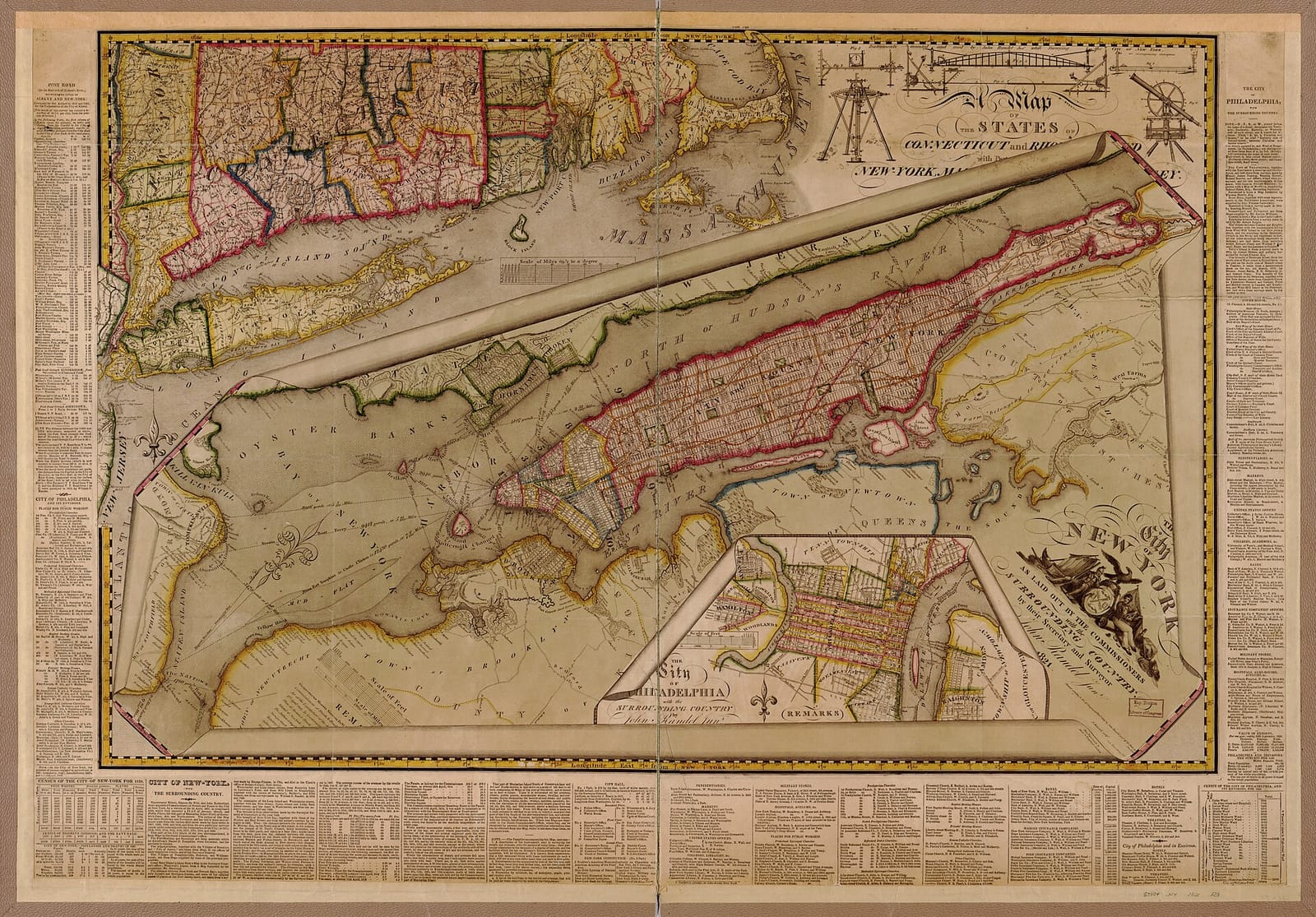
Three men and a young surveyor drew a relentless rectangle over Manhattan, 12 avenues and 155 streets, and explained that right angles were simply cheaper to build. It is why the city looks the way it does.
The facts
- The law
- An 1807 state act gave three commissioners near-absolute power over Manhattan’s streets
- The commissioners
- Gouverneur Morris, Simeon De Witt, and John Rutherfurd
- The surveyor
- John Randel Jr., who placed over 1,500 marble markers and iron bolts across the island
- The plan
- Adopted 1811, a grid of 12 avenues and 155 cross streets, with almost no squares or diagonals
- The reasoning
- The commissioners said "strait sided and right angled houses are the most cheap to build, and the most convenient to live in"
- The exception
- Broadway, an old road that predates the grid and cuts across it
In 1811, three commissioners and a young surveyor decided what Manhattan would look like forever. A state law had given them near-total power over the island’s streets, and rather than the circles and grand diagonals of Washington or Paris, they chose a relentless rectangle: 12 numbered avenues, 155 numbered cross streets, almost no squares, parks, or angles. Their reasoning, written plainly in their official remarks, was money: a city is made of houses, and "strait sided and right angled houses are the most cheap to build, and the most convenient to live in." The surveyor John Randel Jr. spent years staking it out, planting over 1,500 marble markers through farms and over rock, and getting himself arrested for trespass by furious landowners. The one great exception is Broadway, an old road older than the plan, which cuts the grid on a diagonal and opens the squares, Union, Madison, Herald, Times, where it crosses. The grid turned raw Manhattan into uniform, sellable lots, and the city has been built on it ever since.
In their words
The event in the voices and documents of the people who were there. Every source links out so you can check it.
-
Document
The blunt justification for a plain rectangle over anything ornamental: cheapness and convenience over beauty.
A city is to be composed principally of the habitations of men, and that strait-sided and right-angled houses are the most cheap to build and the most convenient to live in.
Remarks of the Commissioners, Gouverneur Morris, Simeon De Witt, and John Rutherfurd, March 1811
Source: Museum of the City of New York, "The Greatest Grid" -
Document
A direct swipe at the baroque diagonals of L’Enfant’s Washington. They considered it and chose against it.
Whether they should confine themselves to rectilinear and rectangular streets, or whether they should adopt some of those supposed improvements by circles, ovals, and stars, which certainly embellish a plan, whatever may be their effect as to convenience and utility.
Remarks of the Commissioners, 1811
Source: Museum of the City of New York, "The Greatest Grid" -
Memoir
Randel spent years staking the future grid across private farms. The angry landowners had him arrested for trespass; a colonel kept posting his bail.
I was arrested by the Sheriff, on numerous suits instituted against me as agent of the Commissioners, for trespass and damage committed by my workmen, in passing over grounds, cutting off branches of trees, &c., to make surveys.
John Randel Jr., recalling the survey, in Valentine’s Manual (1864)
Source: Internet Archive (Randel’s account) -
Document
The grid’s most famous critic, the co-designer of Central Park: every block is interchangeable, so no place is special.
If a building site is wanted, whether with a view to a church or a blast furnace, an opera house or a toy shop, there is, of intention, no better a place in one of these blocks than in another.
Frederick Law Olmsted, report on the Bronx wards, 1877
Source: Olmsted & Croes, 1877 report -
Document
The state, not the city, handed three men near-absolute authority. It is why the grid could override every landowner in its path.
An 1807 state act gave the three commissioners "exclusive power to lay out streets, roads, and public squares" on Manhattan, of whatever "width, extent, and direction" they thought best.
The New York State street-commission act, April 3, 1807
Source: The Commissioners’ Plan of 1811 (records collected) -
Document
The grid’s great exception is not a planned flourish. It is a road the planners could not erase.
Broadway is older than the grid: an Indigenous trail that became the colonial Bloomingdale Road. The commissioners tried to straighten away its diagonal above 14th Street and failed, which is why it slashes across the grid and opens the squares at Union, Madison, Herald, and Times.
Broadway and the grid
Source: Records collected
What people get wrong
-
The myth John Randel Jr. designed the grid.
What’s true He was the surveyor, not the author. The three commissioners set the plan, and its regular-block logic came from earlier 1790s surveys. Randel staked and mapped it; he did not invent it.
-
The myth The grid has no parks because the commissioners forgot.
What’s true They chose minimal open space on purpose, reasoning that the rivers made big parks less necessary and that squares were costly. Central Park came decades later precisely as a correction.
-
The myth Broadway is a diagonal the commissioners drew into the plan.
What’s true Broadway predates the grid. The commissioners tried to erase its diagonal and could not. Every square it creates is an accident of an old road surviving a new plan.
What it changed
- The 1811 plan still defines Manhattan’s streets above Houston Street, the everyday address system of the city.
- By predefining every lot, the grid turned raw Manhattan into uniform, instantly tradeable real estate, the foundation of its land market.
- A few of Randel’s iron survey bolts still sit in the bedrock of Central Park, the ground the grid never reached.
- The grid’s near-total lack of open space drove the campaign that produced Central Park in the 1850s.
The city is still writing this.
We read every newsroom in New York and the state each morning and explain what it means. Free, and the next chapter lands in your inbox.
Free to start. The unsubscribe link actually works.